Red river tales
LALSAWMLIANI TOCHHAWNG
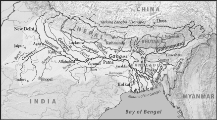
THE fourth largest river in the world, the Brahmaputra, is known by many names as it makes its journey to the sea. It begins as the Yarlung Tsangpo in southwestern Tibet; the Siang, Lohit and Brahmaputra in India; and finally the Jamuna in Bangladesh. It is also known as the Red River when referring to the entire river including the stretch within Tibet. There is a place called Parshuram Kund nestled in the hills of Arunachal Pradesh’s Lohit district. It is a place associated with an origin myth of the Brahmaputra, son of Brahma.
The story goes that the Hindu God of creation, Brahma, sired the river, which was born as a kund or lake. Much later, Parashuram, a Brahmin who had axed his mother to death, arrived there to wash away his terrible sin. The axe had stuck to his hand and all his efforts to get rid of it were defeated. But here, in this place, it came loose. He flung it away with all his might, carving a path through the mountains and a river began to flow. Its waters were red, and so it was called Lohit, from ‘lahu’, meaning blood.
Civilizations have evolved along its banks to coexist with its rhythms. Legends and myths grew around it. Even today, ancient Hindu pilgrimage sites whose origins are lost in time, exist in its remote upper reaches. The river is central to all forms of life, a lifeline to the diverse communities that live along its banks who have a deep and complex relationship with the river. Nature has worked over millennia to weave an intricate web around the waters of the great river and its seasonal ebbs and flows.
As the Yarlung Tsangpo, it is the great river of Tibet. For over 1,600 km (1,000 miles), it flows west to east, north of and parallel to the Great Himalaya Range from its source at Chemayungdung Glacier, near the slopes of Mount Kailas. Its course roughly follows the boundary that marks the seam between the Indian and Eurasian continental plates. Buckled and folded, the mountains to the south block the moist monsoon winds from reaching the Tibetan Plateau. It is a harsh, desolate landscape of mountain, sand and sky with a mighty river flowing through it. Collecting the glacial waters from the north slopes of the great Himalayan peaks, including Everest, the river spreads out for miles in shallow, braided channels, then plunges through short, rocky gorges. It passes to the south of Lhasa and continues to the east for another 480 km (300 miles), seeking a course to the sea through the mountains.
|
|
|
The Third Pole encompasses the snow covered mountains surrounding the Tibetan Plateau. It holds the largest store of permanent ice and permafrost outside the poles themselves. The region also contains the world’s highest peaks, an incredible variety of ethnic communities, and stunning biodiversity (including endangered snow leopards). The Pole’s thousands of glaciers and regular snow melt form the headwaters for 10 of Asia’s biggest rivers, which bring drinking water, power and irrigation directly to 210 million people, while these river basins indirectly support more than 1.3 billion people. |
For much of the last half of the 19th century, an intense debate raged as to what happened to the Tsangpo River, where it disappeared from the map in southeastern Tibet. In a narrow gap, about 320 km (200 miles) wide, four of the major rivers of Asia descend from the Tibetan Plateau confined in great gorges – the Yangtze, the Mekong, the Salween, and the Irrawaddy. Some were convinced the Tsangpo was a tributary of one of these rivers. On the plains of Assam three more rivers unite to form the Brahmaputra – the Lohit, the Dibang, and the Dihang. Others suspected that the Tsangpo River bent sharply to the south and plunged wildly through the heart of the Himalaya to emerge as one of these rivers. And if it did indeed bend to the south abruptly somewhere in southeastern Tibet, by what tremendous passage did it make its descent?
F
ar to the east of Lhasa, the Tsangpo is still a gentle river flowing at more than 305 m (10,000 ft) above sea level. Yet, just over 240 km (150 miles) below, in Assam, the Dihang or Brahmaputra River flows out of the Abor Hills at 150 m (500 ft) above sea level. If indeed the Tsangpo and Dihang were one and the same, geographers speculated that somewhere along its course there was room for a waterfall or series of falls, perhaps to rival Victoria in Africa or Niagara in North America – a new wonder of the world.
|
|
|
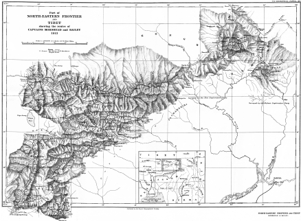
1914 Map of Northeastern Frontier and Tibet. Routes taken by Captains Henry Morshead and F.M. Bailey. Source: Creative Commons . |
Jo Woolf of the Royal Scottish Geographical Society writes – ‘The Lost Falls of the Brahmaputra: the name itself has a fairytale ring to it. These imaginary falls, believed to be as much as a thousand feet high, haunted the dreams of explorers in the 19th and 20th centuries. There was just one problem: they were located deep within the earth’s most inaccessible canyon… In an era that was slightly obsessed with the activity of tracing rivers from source to ocean, India’s mighty Brahmaputra posed a unique puzzle. It was known that its waters emptied into the Bay of Bengal, but where did it begin? If, as suspected by some, its source was the Tsangpo, a river fed by meltwater from the Himalaya, how on earth could it descend 9,000 feet over a distance of just 150 miles, from the Tibetan Plateau to Assam? Surely, a mighty waterfall was the only answer.
I
n 1880 a young Tibetan guide named Kinthup attempted to solve the riddle. He and a Mongolian lama were tasked with gathering logs, carving them with recognizable symbols, and throwing them into the Tsangpo every day for 10 days; British officials would be looking out for them further down. It sounded like a good plan on paper, no doubt, but things went badly wrong from the outset. Kinthup was sold into slavery by his treacherous companion; he escaped, and managed to fulfil his task, but by this time no one was looking out for the descending logs. Kinthup’s story, when it was told, included hair-raising accounts of the canyon’s depth. But the puzzle remained.If devotion to duty was not enough, would craziness provide the answer? A young British officer named Frederick Marshman Bailey was willing to give it a go. Nicknamed "Hatter" Bailey for his daredevil exploits, in 1913 he plunged into uncharted regions of the gorge in the company of another intrepid officer, Henry Morshead. Since Tibet had closed its borders to foreign visitors, and trespassers faced the threat of execution, there could be no outside communication: the pair effectively vanished off the face of the planet for over four months. Not only did they survive capture and imprisonment, but also collected hundreds of natural history specimens, many of which were new to science.
A
nd did they solve the riddle of the Tsangpo Gorge? Well, yes… in part, at least. They saw enough of the Tsangpo to conclude that it did indeed flow into the Brahmaputra, although it seemed incredible. No one had imagined that the raging waters could twist so abruptly around the peak of Namcha Barwa, in a jaw-dropping curve named the "Great Bend". This is the deepest part of the canyon, where the sheer sides drop a mind-boggling 19,700 feet – nearly four miles. Crawling down the treacherous, near-vertical cliffs was an exercise that even Bailey was not willing to attempt.
|
|
|
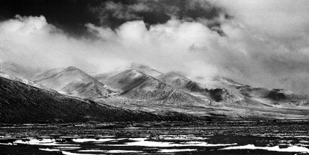
The Yarlung Tsangpo crossing the mountains to enter the southern plateau of Tibet. Photograph: Deb Mukharji. |
Just over 10 years later, in 1924, a little-known English botanist was contemplating precisely the same obstacle. Frank Kingdon Ward was irresistibly lured by the prospect of discovering new and exquisitely beautiful plants. It helped that he would walk eagerly into near-death situations, and was blessed with more lives than the proverbial cat. The trees that fringed the Tsangpo Gorge were festooned with exotic orchids, while the crimson blooms of rhododendrons were almost splashed by the foaming water. Accompanied by his friend and sponsor, the long-suffering Lord Cawdor, Ward picked his way gingerly down into the abyss to collect new species for cultivation. Staggered by the colossal scale of the place, Ward discovered the 70-foot Rainbow Falls and then stood and listened to another cataract, heard but not seen, thundering into the bowels of the earth.
O
nly in recent decades has it been understood that the Tsangpo has no thousand-foot waterfalls; instead, it descends 9,000 feet over 150 miles of continuous rapids, through a gorge that is three times as deep as the Grand Canyon. Not for nothing is the Tsangpo called the Everest of rivers.’It wasn’t until as recently as 1998, that this riddle was finally resolved with the tenacious explorations of Ian Baker, Buddhist scholar, traveller, adventurer and mountaineer who made the arduous and hazardous journey through total wilderness to the unknown reaches of the Tsangpo’s innermost gorges to discover there a world of waterfalls and caves encrusted in crystals. Recounting his expedition for The Independent, Baker writes:
‘For Tibetans, paradise was never lost, just well hidden. Scrolls attributed to an 8th century Buddhist sage describe remote sanctuaries called beyul, secret or hidden lands, deep in the Himalaya where animals and plants are credited with miraculous powers, aging is slowed, and enlightenment can easily be attained. The greatest of these beyul, which inspired these antecedents to the myth of Shangri-La, is said to lie in the heart of Tibet’s Tsangpo Gorge, near the bottom of the earth’s deepest chasm.
The innermost reaches of the Tsangpo Gorge have remained an enigma for centuries. Despite concerted efforts during the British Raj to penetrate its depths, no expedition had ever succeeded, and the area remained as one British field officer had described it, "one of the earth’s last secret places".
…the stories of the beyul, and the Tsangpo Gorge in particular, had captured my imagination. The area had been sealed to the outside world since the Chinese invasion of Tibet during the 1950s but, in 1993, I obtained a permit through a Chinese geological institute to visit the outer edges of the region. Following accounts of earlier explorers, as well as the coded descriptions in the scrolls that I found in the libraries of Tibetan monasteries, I attempted to travel beyond the limits reached by earlier expeditions. But despite my efforts, and rock climbing experience, the inner depths remained as impenetrable as they had been to the British in the 19th and early 20th centuries. In 1998, after a series of attempts to reach the unexplored sections of the Gorge, America’s National Geographic Society sponsored my eighth expedition in which – along with my teammates Ken Storm and Hamid Sardar – we finally reached the area that Tibetans hold to be the portal to their earthly paradise.
Even in strict geographical terms the Tsangpo Gorge is unique. The Tsangpo River flows across the length of the Tibetan plateau until it plunges suddenly into a tangled knot of mountains and gorges at the eastern edge of the Himalayan range, forming a chasm three times the depth of the Grand Canyon. After turning a great arc around a spur of the 25,436 ft summit of Namche Barwa mountain, the river cuts through subtropical jungles and reemerges in northern India as the Brahmaputra, having lost an astonishing 11,000ft in altitude in a mere 50 miles. Nineteenth-century geographers connected to the British Raj’s Survey of India accounted for the drop by imagining a colossal waterfall that they hoped would rival the newly discovered Victoria Falls in Africa, or even Niagara in America. But all efforts to penetrate and map the Tsangpo’s inner gorge met with failure – including forays by spies dispatched to Tibet in the guise of Buddhist pilgrims, with surveying instruments hidden in their prayer wheels.
The last people to search for the legendary waterfall were an English plant-collector named Frank Kingdon Ward and his primary sponsor, a 24-year-old Scottish lord, who ventured into the Gorge in 1924, the same year that George Mallory disappeared into the mists near the summit of Mount Everest… Religious myth or not, nearly 10 miles of the Tsangpo’s innermost chasms remained unknown to the outside world, and the possibility of a waterfall "of a 100 ft or more", as Kingdon Ward had described it, did not seem altogether impossible. I sought out the texts that Kingdon Ward had referred to, but villagers at the threshold of the Gorge told me that, in the years following the Chinese invasion in 1959, People’s Liberation Army troops had forced them to throw them into the Tsangpo. But the knowledge continued in oral memory, and an elderly lama, since deceased, told me of three waterfalls in the depths of the Gorge, the middle one of which, he said, was the door to the promised land at the heart of Beyul Pemako, the "Hidden Land Arrayed Like A Lotus".
"You won’t find paradise by doubting it exists", wrote the poet Byron and, following his dictum, our search for the geographical sources of Shangri-La led us into a vertiginous world of eroding landslides and precipitous subtropical jungles, a place that the plant-collector Kingdon Ward had described disparagingly as "the bowels of the earth".
After weeks of thrashing through pathless forests and across vegetated cliffs, we neared the depths of the Gorge and the largest of the waterfalls that the lama had described to us. We abseiled with climbing ropes down a moss-drenched precipice and finally reached the object of our desire: a waterfall that had eluded the best efforts of the British Raj.
Part of the remit of our expedition was to measure the waterfall as precisely as possible, and the average reading from several vantage points, both above and below, revealed it to be 108 feet: an auspicious figure in Buddhist numerology and surpassing the hopes of turn-of-the-century British geographers. To measure water, though, seemed a futile task; as Heraclitus had said, it all just flows away.
|
|
|
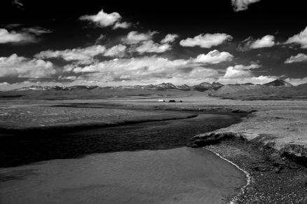
The Yarlung Tsangpo gliding across Tibet’s southern plateau. A nomad’s camp in the distance. Photograph: Deb Mukharji. |
Standing on a sloping ledge at the base of the falls, swirling mists and vegetated cliffs rising into the clouds, we found ourselves at the threshold of the Tibetans’ own Shangri-La. If not a passage to other worlds, we had hoped to find something akin to the Cave of the Winds behind Niagara. But a disciple of the aged lama who had directed us to the falls pointed to something equally compelling: an oval passageway leading into the overhanging cliff across from the waterfall. "That’s the door", he said authoritatively. But several hundred feet of seething white water lay between the opening and where we stood. Sheer rock walls lined the far side of the river. "How do you get there?" I asked, and received the inevitable answer: "You don’t". In the year following our return from the Tsangpo Gorge, the Chinese authorities closed the region to all outsiders…
Ultimately, it matters little whether the legendary paradise in the heart of the Tsangpo Gorge exists physically, or whether it’s a metaphor for the perfection of the human spirit. On the path from ignorance to illumination, the journey is more critical than the destination, and the Buddhist legend of the hidden lands urges us to embrace our highest potential – which must include the preservation of the earth’s last remaining pristine habitats, arguably the only Eden we will ever know.’
|
|
|
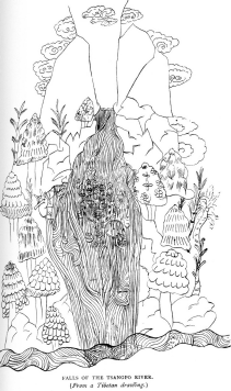
Falls of the Tsangpo: This sketch first appeared in an article by L.A. Waddell in the Geographical Journal (1895) and was later published in his book Lhasa and its Mysteries (1905). A Tibetan lama who had travelled on pilgrimage to the falls drew this sketch. It was later identified by Bailey as the ‘Falls of Shingche Cho Gye’ and located on a side stream flowing into the Tsangpo River, opposite the village of Gyala, at the mouth of the gorge. Bailey believed that this was the falls Kinthup described in his report. It entered Kinthup’s report through an error in transcription as a 150 ft waterfall on the Tsangpo River, a short distance below Pemakochung. Only after Kinthup was interviewed by Bailey after his return from the 1913 expedition was he able to correct the mistake. Or was it a mistake? Could this be the ‘sacred’ Hidden Falls of Dorje Pagmo, located just below Frank Kingdon Ward’s Rainbow Falls? Waddell describes the setting: ‘Their height is estimated at about 70 feet, and they are enveloped, as shown in the picture, by clouds of mist and spray, and the cliffs are covered by subtropical vegetation, and tiger lurk in the neighbourhood.’ Source: Riddles of the Tsangpo Gorges, 1999. |
B
y the time the Brahmaputra is ready to enter the plains of Bangladesh, it is a roaring, rampaging river, thundering down in this the last stage of its journey before joining the Bay of Bengal. The land is no match as it tears this way and that, carving new courses every year, creating islands in the river one year, destroying them the next. Turning south around the Garo Hills below Dhuburi in India, it enters Bangladesh crossing a border it does not recognize. After flowing past Chilmari, Bangladesh, it is joined on its right bank by the Teesta River and then follows a 150 mile (240 km) course due south as the Jamuna River, undergoing a change in gender along the way. In the relative plains of Bangladesh, the river that is a single mighty course one year, within a couple more can turn into a watery braid, dotted with islands.
A
s in Assam, Bangladesh’s poorest farmers grow fat or thin, prosperous or desperate, according to the river’s whims. If you are a poor Bengali peasant and have nothing at all and with a family to feed, these sandy chars (a Bengali term for unstable river islands) are the place to head. These sandy knobs are land without people, fresh-minted, claimed by no landlord or government, free of gates and fences, there for the taking. What grows on sand? Not much, but sand can be sold to the construction industry in Dhaka. Or the sand mixed with the fertilizing silt that the river carries from the Himalaya and within months catkin grass begins to grow, providing thatch for the roofs of new houses, fences, fodder for cattle, it can be dried for fuel and when the char floods, the grass can be piled into high mounds where people and cattle can take refuge from the water.|
|
|
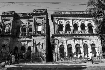
Crumbling houses of Panam Nagor: Located close to Dhaka in Bangladesh, the ghost town of Panam city or Panam Nagor, in Sonargaon, a former Hindu settlement dating to the early 13th century. The striking Indo-European architecture of the many grand town houses, now abandoned, presents a ghost town appearance. Source: Creative Commons. Photograph: Fahad Faisal, 2016. |
However, the people of the chars are the most vulnerable, created by the rivers’ caprice, there is absolutely no way of knowing how long a char can keep its head above the waters. As the roaring river often does with unpredictable frequency, changing its course and sweeping everything in its path creating new chars where none existed before. And for the peasants, the cycle of finding a newly minted char and rebuilding afresh begins all over again.
I
n 1787 the river changed its course and split into two distributary branches. The main western branch which contains the majority of the river’s flow continues due south as the Jamuna to merge later with the lower Ganga, called the Padma. The eastern branch, formerly the much larger, but now much smaller, is called the Lower or Old Brahmaputra. South of Gaibanda, the Old Brahmaputra leaves the left bank of the main stream and flows past Jamalpur and Mymensingh to join the Meghna River at Bhairab Bazar.
A
t the site where the Old Brahmaputra and Meghna rivers converged, Sonargaon arose. Sonargaon or the ‘Golden City’ was the eastern capital of Bengal at various times throughout Bengal’s pre-Mughal history and prior to the 13th century, the centre of Hindu power. Its strategic location helped to enhance its importance making it a perfect base for trading the famous Bengal muslin cloth and as an international centre for trade with a number of specialized industries which sprang up to support it.The city has been described by a number of well known travellers, including Ibn Battuta, Ma Huan, Niccolò de' Conti and Ralph Fitch as a thriving centre of trade and commerce. However, when the Mughals took power in the 17th century, they saw Dhaka as more strategically protected from the Arakanese invaders and therefore decided to relocate the capital to Dhaka. And with the advent of colonial rule, the British destroyed almost all the textile skills. From that time onwards, the area experienced serious decline and not many of its historic buildings remain. Today, Sonargaon has a ghost town feel to it, where grand mansions of merchant families stand silently in splendid decay, these aging rajbaris, now an empty, mossy crumbling museum of successive histories.
|
|
|
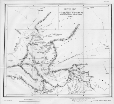
‘Kinthup’s map’ drawn by Col. Tanner from, information ‘supplied by K.P. in 1886-1887.’ It was published in 1889 to accompany Kinthup’s Report, Dehra Dun. The ‘Falls of the Sangpo’ appear on the map for the first time. Many of the place names correspond with the names of today |
B
efore its confluence with the Ganga, the Jamuna receives the combined waters of the Baral, Atrai, and Hurasagar rivers on its right bank and becomes the point of departure of the large Dhaleswari River on its left bank. The Jamuna joins with the Ganga north of Goalundo Ghat. Located at the confluence of the two rivers, Goalundo Ghat is where the Dacca Mail of the Eastern Bengal State Railway terminated and the passengers boarded a steamer for the journey to Narayanganj, the port of Dacca; disembarked at Chandpur to catch Assam Bengal Railway’s metre gauge mail to Chittagong; or, journeyed up the Brahmaputra to Assam. As the Padma, their combined waters flow to the southeast for a distance of about 120 km.After several smaller channels branch off to feed the Ganga-Brahmaputra delta to the south, the main body of the Padma reaches its confluence with the Meghna River near Chandpur and then enters the Bay of Bengal through the Meghna estuary and lesser channels flowing through the delta. The Meghna forms the eastern limit of the Sundarbans, a vast tract of forest and saltwater swamp that constitutes much of the Ganga-Brahmaputra delta, the world’s largest delta.