Southeast Asia and maritime security
RISTIAN ATRIANDI SUPRIYANTO
GEOGRAPHY determines where the Bay of Bengal (BoB) and Southeast Asia meet. According to the 3rd edition of the S-23 publication of the International Hydrographic Organization (IHO) on the ‘Limits of Oceans and Seas’, the BoB is enclosed on the east by ‘[a] line running from Cape Negrais (16 degrees 3 minutes North) in Burma through the large islands of the Andaman group’, and on the south by ‘Adam’s Bridge (between India and Ceylon) and from the southern extreme of Dondra Head (south point of Ceylon) to the north point of Poeloe Bras [Pulau Breueh]’ near Sumatra.
1 The 3rd edition of S-23 separates the BoB from the Indian Ocean. Unlike the 3rd edition, the draft 4th edition of the S-23 classifies the BoB as a subdivision of the Indian Ocean.2Yet, the 4th edition ‘is only a working document’ since the ‘voting process’ for approval ‘was interrupted by the [International Hydrographic Bureau] directing committee in September 2002.’
3 Regardless of such disagreements, the BoB has been historically, politically, socially and culturally a part or a sub-geographical division of the Indian Ocean.4 The cartographic confines, as per 3rd edition of the S-23, mean there are five littoral states of the BoB – Bangladesh, India, Indonesia, Myanmar (Burma), and Sri Lanka (Ceylon).The geographical confines of Southeast Asia are more difficult to define, partly due to the absence of an IHO-like institution to delimit regional borders. Southeast Asia thus became known as such (and not, for instance, Southwest Asia) based on the location of the viewer.
5 After all, where South Asia ends and Southeast Asia begins fundamentally rests on what David Brewster described as the ‘mental map’, or ‘a person’s subjective perception of their area of interaction.’6 Whereas both Indonesia and Myanmar belong to Southeast Asia, neither belongs to South Asia, despite that they are littoral countries of the Indian Ocean and, specifically, of the BoB. Simply put, land and islands rather than oceans and seas, dominate the mental map of policy makers.Whereas the BoB clearly unites Southeast Asia with South Asia, that is, Indonesia and Myanmar with India, Bangladesh, and Sri Lanka, the present mental maps of policy makers dictate the two regions to be separate and distinct. The land-centric separation and division in mental maps render the BoB to appear spatially further from Southeast Asia than, say, the South China Sea or the Sulawesi Sea. Yet, challenges to maritime security are neither aware nor respectful of such separation and distinction. In fact, the barrier-less and border-less nature of the sea, unless punctuated by land features, is the very reason people use the sea, for good or ill. Thus, with the aid of regular monsoon winds the BoB has been ‘for centuries the maritime thoroughfare between India and China.’
7
S
ince maritime security is a ‘buzz-word’ whose meaning ‘will always vary across actors, time and space’, this study defines maritime security merely as the absence of challenges in the use of the sea.8 Most pertinent challenges to maritime security in the BoB are demographic, environmental and strategic in nature.9 Bengal is one of the world’s most densely populated regions. The BoB littoral states have a combined population of around 37% of Asia’s total.10 In July 2017, Bangladesh alone had a population of more than 150 million, a majority of whom live in poverty (daily spending of less than two US dollars).11 Surrounded by mountain ranges on the north, northeast and southeast, most of the population in the BoB region live on the Ganges-Brahmaputra delta system prone to extreme tidal movements and monsoon storms. The demographic composition is also diverse. Almost all of the world’s major religions have their adherents here, including Islam, Hindu, Buddhism, Christianity and Jainism. This diversity is present irrespective of political boundaries of the littoral states. Tamils and Sinhalese dominate the southwestern end of the arc-shaped BoB littoral; the Arakanese (and the Rohingya), Andamanese and Acehnese inhabit the southeastern; while the Bengalis reside on the northern, not to mention many other ethnic groups who live amongst them.
P
overty, high population density, disaster prone environmental terrain, and rich ethno-religious diversity present demographic challenges with maritime consequences. These challenges can manifest in tougher competition for resources, which will drive people further and deeper into the BoB. Instead of moving inland, demographic challenges will likely drive most population to move along the littoral in search of better lives. For instance, the conflict in the Rakhine state of Myanmar drove most of the Muslim majority ethnic Rohingya (whose existence the Myanmar government refused to recognize) into refugee camps along the Bangladesh-Myanmar coastal border. The UNHCR estimated that over 670,000 Rohingya have fled to Bangladesh since 25 August 2017.12 The problem might worsen due to India’s potential deportation of the 40,000 Rohingya now thought to be living in the country.13 Similarly, the end of civil war in Sri Lanka scarcely reconciled the antagonism between the Tamils and Sinhalese.14
G
iven that these conflicts exist on land, refugees tend to escape along the littoral arc and/or towards the sea. Migration related maritime incidents could rise as a result.15 The maritime influx of refugees could add to existing demographic concerns in other BoB littoral countries. For instance, the arrival of migrant boats on the coast of Aceh in Indonesia has occasionally triggered resentment within the local population and authorities.16The demographic challenges interfere with the natural environment. Tougher competition for resources drives people to use the oceans more exploitatively. Overfishing and marine pollution are two challenges that will only worsen. A 2017 report found that fishing ‘dead zones’ in the BoB ‘have expanded over the past decades’ as evident in the depleting oxygen content.
17 If unchecked, the water could become devoid of nitrogen, a key nutrient for marine ecosystems. Economic over-exploitation, poor waste management and climate change can combine to produce unpredictable consequences on the environmental conditions of the BoB.18 The expansion of population and industrial centres upstream and along the littoral discharges larger amount of pollution into the BoB.
A
2016 study found that heavy metal (cadmium, chromium, copper, mercury, nickel, lead, uranium) pollution in the littoral waters of Bangladesh was a result of direct discharge of agricultural, domestic and industrial wastes from rivers upstream. Moreover, the study noted that the pollution ‘hot spots’ are usually areas with ‘significant ecological values since these waterways support commercial fisheries, recreational activities, natural breeding, and nursing breeding and nursing grounds of native fish, prawn/shrimp and other ecosystem goods and services including rural livelihoods.’19In addition, rising sea levels due to climate change could displace a large portion of the coastal population, especially in the Ganges and Brahmaputra delta where the average elevation is no more than ten metres above sea level. Chellaney argued that the sea ‘has already swallowed about 100 square kilometres of the 9,360 square kilometre mangrove swamps of Sunderbans’ since ‘the sea is rising at 3.14 millimetres a year in the Sunderbans as against a global average of 2 millimetres.’
20Two worrying trends could emerge as a result of the demographic and environmental challenges. First, the rate of resource exploitation will likely outpace the rate of the environment to be able to recover and replenish itself. This could create what Andrew Mack called ‘the tragedy of the commons’; that uncoordinated and self-interested exploitation of the sea will mean less gain for all: since every-one felt they are entitled to marine resources therein, none felt responsible enough for the sustainability of such resources.
21 Second, environmental degradation and depletion of natural resources in combination with displaced coastal populations could become a recipe for communal disputes or conflicts, which could be easily exploited and thus magnified by ethnic and/or religious sentiments.22 The so-called ‘climate refugees’ will compete among themselves and against their potential hosts not just for space, but for sustenance as well.23
T
he demographic challenge and environmental degradation can inadvertently complicate the present strategic situation in the BoB. The BoB is located on the western approaches to the Strait of Malacca and Singapore. The US Energy Information Agency estimated that nearly one-third of the 61% of petroleum and its derivatives that moved on maritime routes transited the Malacca Strait in 2015.24 Refugees fleeing in boats from Bangladesh, Myanmar and Sri Lanka could disrupt the flow of oil shipment through the BoB. The sight of migrant boats in danger obliges ships, including oil tankers in the vicinity, to offer assistance.Moreover, social dispossession and conflict over marine resources could force the poor to seek alternative, often illegal, livelihoods. They may resort to criminal activities, such as maritime poaching, piracy (already a problem off Bangladesh) or even terrorism.
25 High underemployment and unemployment in the fishery sector of Myanmar forced many fishermen into slavery on Thai boats, often lured by human traffickers promising higher wages and better working conditions.26 The expanding dead zones and worsening pollution in the BoB could force fishermen from the littoral states to sail further afield, thus adding problems in ecologically sensitive areas beyond the BoB, such as the Andaman Sea. In turn, this trend could precipitate disputes and even conflicts among littoral fishermen, such as those between India, Bangladesh and Myanmar.27
T
he aforementioned maritime security challenges also apply to the Southeast Asian littoral countries of the Bob – Myanmar and Indonesia.28 The Myanmar government’s refusal to recognize the Rohingya as one of its indigenous nationalities delegitimizes the Rohingya’s centuries-old presence in Myanmar. Meanwhile, facing their owndemographic pressures and security concerns, Bangladesh and India appear incapable and/or unwilling to accommodate more Rohingya refugees within their borders. The situation has left the fate of the Rohingya in limbo. Many took to the sea in search of better lives overseas. But many also failed to reach their destinations. The solution rests on land where Bangladesh and Myanmar, as well as the international community, must find a new settlement for the Rohingya as the world’s ‘most persecuted minority.’29 Myanmar and Bangladesh have begun talks to repatriate Rohingya refugees, although their progress seems in doubt.30
E
ven Myanmar’s economic improvement may not lead to a better treatment of the Rohingya. In fact, it could produce precisely the opposite effect. Ravi Balaram contemplated a scenario where Myanmar’s expanding offshore oil and gas industries could ‘exacerbate several human rights issues’ with regard to the Rohingya. Not only could offshore industries erase the Rohingya’s subsistence fishing villages, but such industries could also develop infrastructure related to resource extraction whose ‘property rights and environmental issues could displace the Rohingya.’31 The failure to address the Rohingya issue properly could unleash more migrant related maritime incidents since many Rohingya’s would try to escape from refugee camps whose conditions are often squalid and inhumane.
F
or Indonesia, on the other hand, demographic pressures are less prominent ever since the conclusion of the peace agreement between the government and the separatist Aceh Independence Movement (Gerakan Aceh Merdeka, GAM) in 2005. Peace allowed the Acehnese to rebuild and even shelter some overseas refugees including the Rohingya’s. Nevertheless, there is a concern whether peace means anything other than the absence of war. Aceh is Indonesia’s only province that follows the Islamic Sharia penal code, which applies to non-Muslims as well. Although the introduction and implementation of the Sharia has so far been relatively peaceful, it generates resentment and antagonism from civil and human rights groups who see the Sharia as being draconian.32 The application of Sharia is unlikely to trigger another civil war, but tension between Jakarta and Aceh over alleged excesses and abuses of Sharia application is a possibility.Equally critical for both Myanmar and Indonesia are issues of an environmental nature. Poaching has been a pertinent and persistent challenge to Myanmar’s maritime security. Since the early 1980s, Thai fishing trawlers have been operating in Myanmar’s waters, which resulted in ‘an extended period of over-exploitation’ and depleted marine resources.
33 Part of the blame rested on Myanmar’s military government whose decision to grant fishing rights to Thai trawlers in December 1988 not only opened the floodgate for foreign fishermen (both legal and illegal) to Myanmar’s waters, but also made the issuance of licenses prone to abuse and corruption. Myanmar’s naval officers had been notorious ‘for taking bribes from Thai trawlers in exchange for turning a blind eye to illegal fishing.’34
W
hile the Thais are to blame for many of the ills, the locals cannot be totally absolved from the responsibility of marine environmental degradation. Overfishing and illegal logging of mangrove trees have degraded the quality of Myanmar’s marine environment at an alarming rate, although this trend has been declining since the 2000s.35 Maritime poaching is also a big concern for Indonesia. The incumbent President Joko Widodo introduced the toughest anti-maritime poaching policy Indonesia has ever seen. The policy includes theatrical demolition of confiscated fishing boats as a ‘shock therapy’ and deterrent for potential poachers.36 Areas where rampant maritime poaching takes place include the Malacca Strait, the Indonesian EEZ in the South China Sea and the seas of eastern Indonesia.
I
n the Indonesian portion of the BoB, maritime poaching appears to be less severe than that of Myanmar. The Indonesian Fishery Ministry reported that Acehnese waters are prone to maritime poaching from Malaysian and Thai fishing boats. Although the report is unclear on whether these boats had been operating in the BoB, they certainly had the capacity to do so.37 In 2005, there was concern about overfishing due to an oversupply of boats from aid delivered in the aftermath of the 2004 Indian Ocean earthquake and tsunami.38 Indeed, the Reef Check Foundation suggested in 2006 ‘sedimentation (exacerbated by the tsunami), overfishing, and the use of destructive fishing methods may represent a greater threat to Aceh’s reef ecosystems than the immediate impacts of the earthquakes and tsunami.’39Demographic and environmental issues complicate the strategic situation in Myanmar and Indonesia. In Indonesia, the problem of piracy and sea robbery arose as a result of the separatist insurgency in Aceh. Consequently, piracy and sea robbery incidents in the area spiked when the GAM was aggressively challenging the Indonesian central government in 1998-2004.
40 In June 2005, the Lloyd’s Joint War Committee declared the Malacca Strait a ‘war-risk’ area, which drew protests from the littoral states and shipping community.41 Such protests were legitimate and credible, for there were 45 piracy incidents in 2004 which ‘accounted for only 0.07% of the total number of ships transiting the strait that year.’42 Between 2000 and 2004, attacks against ships only ranged from 0.06 to 0.19%.
N
otwithstanding, counter-piracy was the main reason for Indonesia, Malaysia and Singapore to initiate the Malacca Strait Sea Patrol (MSSP) in July 2004.43 The same reason motivated India and Indonesia to commence the biannual India-Indonesia naval coordinated patrols (IndIndo Corpat) since 2002 along the Six-degree channel where the maritime boundary between the two countries is drawn.44 Counter-piracy efforts among the littoral states, precautionary measures by ship crew, and the 2004 tsunami seem to have reduced piracy incidents significantly.45Like the case of maritime poaching though, maritime piracy in Indonesia tends to be concentrated along the funnel of Malacca Strait (eastern waters of Aceh) where ships sail much closer to land and, for navigational safety reasons, tend to sail slower. By comparison, the Indonesian portion of the BoB is less prone to piracy than the Malacca Strait. The ReCAAP Information Sharing Centre reported that in 2008-2017 there were only six piracy and sea robbery incidents in the BoB, as opposed to 241 incidents in the Strait of Malacca and Singapore.
46
T
he relative security of Myanmar from piracy and sea robbery may belie the real concern occupying Naypyidaw’s mind. Maung Aung Myoe points to maritime boundary disputes as Myanmar’s foremost maritime challenge.47 Having settled the maritime boundary dispute with Bangladesh in March 2012, Haacke notes Myanmar still faces a challenge from the US which regards Myanmar’s straight baselines and claimed EEZ as ‘excessive maritime claims.’48 With less domestic political pressures, however, Myanmar may now turn its attention slightly outward and seaward. The political reforms in 2010-2015, which increased civilian presence in government, have somewhat lessened domestic pressures on Naypyidaw. Energy security can further motivate the Myanmar government to defend its maritime claim. The lifting of western economic sanctions against Myanmar drove international oil and gas companies to exploit Myanmar’s seabed. In 2013, Myanmar awarded 20 offshore blocks to such companies.49
T
he domestic political shift and a heightened concern over offshore energy and fishery resources may have driven Myanmar’s recent decision to embark on modest naval modernization. Table 1 shows that Myanmar has acquired seven principal surface combatants (frigates and corvettes) in 1998-2017. On 24 December 2017, the Myanmar navy acquired its first Offshore Patrol Vessel (OPV).50 Although the submarine has been in Myanmar’s wish list since 2000s, the likelihood of purchase is higher at present given Myanmar’s better financial conditions.51 Jane’s reported a small contingent of Myanmar Navy personnel had undertaken submarine warfare training with the Pakistani Navy in Karachi in April/May 2013.52 Myanmar’s naval modernization plans aim ‘to develop a blue-water capability’ which includes the acquisition of eight frigates and two submarines.53 Jon Grevatt suspected Myanmar’s submarine ambition is ‘a direct result of neighbour and rival Bangladesh’s recent commission of first-ever submarines.’54 Bangladesh, on the other hand, acquired two Chinese Type 035 Ming-class SSK for USD 203 million which ‘will make strategic calculations more complex for any would-be aggressor.’55|
TABLE 1 Naval Fleet Compositions of Indonesia and Myanmar |
||||||
|
Types |
1998 |
2007 |
2017 |
|||
|
Indonesia |
Myanmar |
Indonesia |
Myanmar |
Indonesia |
Myanmar |
|
|
Principal surface combatants |
33 |
0 |
28 |
3 |
32 |
7 |
|
Patrol and coastal combatants |
57 |
65 |
37 |
59 |
64 |
54 |
|
Amphibious |
26 |
15 |
27 |
11 |
24 |
9 |
|
Mine warfare |
13 |
0 |
12 |
0 |
8 |
0 |
|
Logistics and support |
15 |
15 |
16 |
16 |
23 |
19 |
|
Submarines |
2 |
0 |
2 |
0 |
3 |
0 |
|
Naval aviation |
114 |
0 |
87 |
0 |
92 |
0 |
|
TOTAL |
260 |
95 |
209 |
89 |
246 |
89 |
|
Source : International Institute for Strategic Studies, The Military Balance 1998; The Military Balance 2007; The Military Balance 2017. |
||||||
T
he Bangladesh-Myanmar naval competition will complicate the strategic situation in the BoB where several major naval forces already operate. India, China and the United States consider the BoB as within their naval strategic reach.56 China’s naval operation in the Indian Ocean must first transit the BoB. Wary of Chinese naval expansion into the BoB, India may intensify operations to detect, identify and potentially track Chinese naval traffic passing through the axis between Visakhapatnam and Port Blair where Indian main naval bases are located; as well as the Six-degree channel between Aceh and the Great Nicobar Island. In addition, India has been selling arms to Myanmar to ‘countering China’s political, military, and diplomatic influence over Naypyidaw.’57 China’s geostrategic inroads into Myanmar, Sri Lanka, and Bangladesh, as part of the ‘string of pearls’ in the Indian Ocean, are causing consternation in New Delhi.58 In response, India is becoming supportive of Washington’s desire to keep China’s military presence out of the Indian Ocean. The 2017 iteration of the Indo-American naval exercise ‘Malabar’ invited the Japan Maritime Self Defence Force, saw the deployment of their most capable naval assets, including aircraft carriers and maritime patrol aircraft for anti-submarine warfare.59 China, on the other hand, had long suspected the Malabar exercises as conveying the Indo-American intent to oppose China’s legitimate military presence in the Indian Ocean.
I
n light of the competitive strategic situation in the BoB, Indonesia plans to station more military presence off Aceh. Although details are murky, it is possible that Indonesia’s planned Joint Regional Defence Commands (Kogabwilhan) may include Sabang on Weh Island.60 Sabang’s location is ideal to monitor maritime traffic between the BoB and the Malacca Strait. The Indonesian government seems to have realized the strategic importance of the channel between Weh and the Great Nicobar Islands. Since 2002, the channel has been the location of the IndIndo Corpat. In 2015, these patrols expanded to include a bilateral maritime exercise, which highlighted Indonesia’s increased attention towards the Indian Ocean. In mid-2016, Indonesia hosted three multilateral naval events back-to-back.61
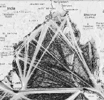
T
he hosting of such events is also indicative of Indonesia’s growing appreciation of international naval diplomacy.62 Since 1995, for instance, Indonesia has been a regular participant in India’s ‘Milan’ multilateral naval exercise. With increased density of shipping traffic through the BoB, there is a potential expansion of Indo-Indonesian naval ties. Map 1 demonstrates that the axis of yellow lines between Indonesia’s Aceh and Sri Lanka’s southernmost point of Dondra Head is where shipping density in the BoB looks highest. The axis is where India, Indonesia and Sri Lanka could initiate collaborative efforts to maintain the security and safety of navigation.In spite of their valuable contribution, the present institutional arrangements seem ill-fitted to the maritime security requirements and challenges in the BoB. The sole multilateral cooperation agreement – the Bay of Bengal Initiative for Multi-Sectoral Technical and Economic (BIMSTEC) – only accommodates four littoral states (Bangladesh, India, Sri Lanka and Myanmar) and excludes Indonesia. BIMSTEC is also traditionally averse to discussions of security, let alone of a military nature. Only in 2016 did BIMSTEC address maritime security and strategic issues, but the concrete outcome is yet to be seen.
63 The other multilateral cooperation, the Indian Ocean Rim Association (IORA) and the Indian Ocean Naval Symposium (IONS) are pan-regional in scope and multitude in membership, which may deny specific attention and action towards the BoB. What the BoB needs instead is somewhere between the two extremes of peculiarity and universality. It must be inclusive of all littoral states and attentive to all issues of relevance to the littoral states.|
|
|
Geographical re-imagination. |
A
s a first step, the littoral countries must ‘re-imagine’ the BoB as a single geographical unit. The border-less and barrier-less nature of the sea means that problems in one area can quickly shift to another. Individual and fragmented efforts by the littoral countries will only move problems in and around the BoB but will not eliminate them. This means that any response from the littoral countries to the aforementioned maritime security challenges must be collective if their solutions are to be effective. As soon as this is workable, the littoral countries can also consider the following thoughts.
F
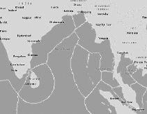
irst, the littoral countries must fill the gaps in the present maritime security cooperation. Whereas most cooperation activities are issue-centric (e.g. illegal migration, marine conservation, etc.), they need to become region-centric. It can manifest in the expansion of BIMSTEC to include Indonesia and/or the establishment of a new institution more reflective of littoral countries’ interests, such as in naval risk reduction measures and non-traditional maritime security threats.64Second, in cases where multi-lateralism is difficult, there should be more cooperation in bilateral or trilateral format. For instance, there could be trilateral naval patrols between India, Indonesia, and Sri Lanka along the Aceh-Dondra Head axis. Another possibility is the establishment of a joint maritime surveillance centre to monitor the India-Indonesia maritime boundary in the Six-degree channel. The centre can take cues from the Indonesia-Singapore Project SURPIC II in real time surface surveillance of the Singapore Strait.
65 Map 2 shows that the maritime, namely the EEZ, boundaries of India, Sri Lanka, and Indonesia are contiguous enough to allow the establishment of a joint maritime surveillance initiative.Third, the littoral countries can promote collective efforts in fishery management, disaster response as well as search and rescue (SAR). They could adopt the regional plan of action (RPoA) on fisheries,
66 establish a joint fishery monitoring agreement and information sharing centre to ascertain fish stocks and enforce fishing quotas as a way to prevent over-fishing. A regional protocol on SAR and disaster response would also be helpful in promoting interoperability during joint responses to natural and man-made emergencies, including maritime migration incidents.|
|
|
Maritime boundaries of the littoral states. |
F
inally, there could be initiatives to establish broader connectivity among the littoral countries. The Master Plan on ASEAN connectivity calls for ‘integrated and seamless multimodal transport systems’ in the Mekong-India Economic Corridor (MIEC) through the Bay of Bengal and Andaman Sea.67 Additional maritime connectivity routes could be possible between Aceh and the Great Nicobar Island, as well as between Myanmar and the Andaman Islands. At the time of writing, there is no commercial transport link between the Nicobar Islands and Aceh despite their close proximity. It might have been more efficient logistics-wise for the population in the Andaman and Nicobar Islands to import consumer and other goods from Aceh than from the Indian mainland.The barrier-less and border-less nature of the sea means the mental map division between South and Southeast Asia is irrelevant. Maritime security challenges in one area, if unaddressed, can easily spill over to other areas. The demographic challenges of poverty, high population density and ethno-religious diversity can manifest in communal conflicts that will lead to a rise in illegal migration and migrant-related maritime incidents. The demographic challenges can interfere with the natural environment. Overpopulation can lead to higher competition over access to marine resources which will contribute to over-exploitation of the environment. Demographic and environmental issues, in turn, can create or exacerbate such strategic challenges as maritime piracy and terrorism, poaching, and even naval rivalry.
B
oth Indonesia and Myanmar face all of the aforementioned challenges. Myanmar’s Rohingya problem exemplifies the case of a migrant related maritime security challenge. If unaddressed, migrant related problems could manifest into something more serious, such as maritime piracy and poaching, which seem to be Indonesia’s two foremost maritime security challenges. Such problems could complicate the present strategic situation in the BoB, characterized by growing competition between the naval powers of China, India and the US.In response to and in anticipation of the strategic and other challenges outlined above, Indonesia and Myanmar must re-imagine the BoB as a single geographical unit. Following which the two countries could consider making maritime security cooperation in the Bob more region-centric; establish more cooperation in bilateral and trilateral format; promote collective efforts in fishery management, disaster response and SAR; as well as build broader maritime connectivity among the BoB littoral countries.
Footnotes:
1. International Hydrographic Organization, Limits of Oceans and Seas (Special Publication No. 53), 3rd ed., IHO, Monaco, 1953, p. 21.
2. ‘IHO Publication S-23: Draft 4th edition’, 2002, https://www.iho.int/mtg_docs/com_ wg/S-23WG/S-23WG_Misc/Draft_2002/Draft_2002.htm
3. For example, the disagreement between Japan and South Korea over the naming of ‘Sea of Japan’ (Japan) or the ‘East Sea’ (South Korea). https://www.iho.int/mtg_docs/com_ wg/S-23WG/S-23WG_Misc/Draft_2002/Draft_2002.htm
4. Sunil Amrith, Crossing the Bay of Bengal: The Furies of Nature and the Fortunes of Migrants. Harvard University Press, Cambridge, 2017, p. 27.
5. The examples of Allied division of command in WW II are illuminating. While the British regarded the area as the ‘South East Asia Command’ (SEAC), the Americans classified the region as the ‘South West Pacific Area’ (SWPA).
6. David Brewster, ‘Dividing Lines: Evolving Mental Maps of the Bay of Bengal’, Asian Security 10(2), 2014, p. 152.
7. S. Amrith, Crossing the Bay of Bengal, op. cit., p. 13.
8. Christian Bueger, ‘What is Maritime Security?’ Marine Policy 53, 2015, p. 163.
9. S. Amrith, Crossing the Bay of Bengal, op. cit., pp. 5 & 9-13.
10. Brewster, ‘Dividing Lines’, op. cit., p. 153.
11. Data from the Asian Development Bank shows that 31.5% of Bangladeshis live below the national poverty line, and 73.5% of the employed population live below USD1.90 purchasing power parity. Asian Development Bank, ‘Poverty in Bangladesh’, https://www.adb.org/countries/bangladesh/poverty; Central Intelligence Agency, ‘South Asia: Bangladesh’, The World Factbook, https://www.cia.gov/library/publications/the-world-factbook/geos/bg.html
12. UNHCR, ‘Rohingya Emergency’, http://www.unhcr.org/rohingya-emergency.html
13. Krishna Das and Sanjeev Miglani, ‘India Says to Deport All Rohingya Regardless of U.N. Registration’, Reuters, 14 August 2017, https://www.reuters.com/article/us-myanmar-rohingya-india/india-says-to-deport-all-rohingya-regardless-of-u-n-registration-idUSKCN1AU0UC
14. SBS Radio, ‘Why do Asylum Boats Keep Coming From Sri Lanka?’ SBS News, 3 September 2013, https://www.sbs.com.au/news/why-do-asylum-boats-keep-coming-from-sri-lanka
15. For instance, see, ‘Rohingya Crisis: "About 60 Dead" in Boat Capsize’, BBC News, 29 September 2017, http://www.bbc. com/news/world-asia-41432573
16. Australian Associated Press, ‘Indonesia Waits for Better Weather Before "Escorting" Boat Arrivals Back to Sea’, The Guardian, 18 June 2016, https://www.theguardian. com/world/2016/jun/18/indonesia-sri-lanka-boat-asylum-seekers
17. L.A. Bristow, et. al., ‘N2 Product Rates Limited by Nitrite Availability in the Bay of Bengal Oxygen Minimum Zone’, Nature Geoscience 10, January 2017, p. 24.
18. Amitav Ghosh and Aaron Lobo, ‘Bay of Bengal: Depleted Fish Stocks and Huge Dead Zone Signal Tipping Point’, The Guardian, 31 January 2017, https://www.theguardian. com/environment/2017/jan/31/bay-bengal-depleted-fish-stocks-pollution-climate-change-migration
19. Golam Kibria, et al., ‘Trace/Heavy Metal Pollution Monitoring in Estuary and Coastal Area of Bay of Bengal, Bangladesh and Implicated Impacts’, Marine Pollution Bulletin 105, 2016, pp. 393 & 399.
20. Brahma Chellaney, ‘Indian Ocean Maritime Security: Energy, Environmental and Climate Challenges’, Journal of the Indian Ocean Region 6(2), 2010, pp. 161-62.
21. Andrew Mack, ‘Security Regimes for the Oceans: The Tragedy of the Commons, the Security Dilemma, and Common Security’, in Jon M. Van Dyke, Durwood Zaelke and Grant Hewison (eds.), Freedom of the Seas in the 21st Century: Ocean Governance and Environmental Harmony. Island Press, Washington DC, 1993, pp. 409-10.
22. B. Chellaney, 2010, op. cit., pp. 162-63.
23. Rafael Reuveny, ‘Climate Change-Induced Migration and Violent Conflict’, Political Geography 26(6), 2007, p. 659.
24. Lejla Villar and Mason Hamilton, ‘The Strait of Malacca, a Key Oil Trade Choke-Point, Links the Indian and Pacific Oceans’, EIA, 11 August 2017, https://www.eia.gov/todayinenergy/detail.php?id=32452
25. Gayathri Iyer, ‘Common Responses to Maritime Security Threats in the Bay of Bengal’, ORF Issue Brief No. 208, Observer Research Foundation, New Delhi, 2018, p. 6.
26. See, AP Investigation, ‘Seafood From Slaves’, 2015, https://www.ap.org/explore/seafood-from-slaves/
27. For example, see Khondker Murshed-e-Jahan, Ben Belton and Kuperan Viswanathan, ‘Communication Strategies for Managing Coastal Fisheries Conflicts in Bangladesh’, Ocean and Coastal Management 92, 2014, pp. 65-73.
28. Thailand is not a littoral state of the BoB since the Thai-Indian Ocean coastline only meets the Andaman Sea (see Map 2).
29. ‘Myanmar: Who are the Rohingya?’ Al Jazeera, 30 November 2017, http://www. aljazeera.com/indepth/features/2017/08/rohingya-muslims-170831065142812.html
30. AFP, ‘Myanmar, Bangladesh in Angry Exchange Over Delayed Rohingya Repatriation’, Bangkok Post, 24 January 2018, https://www.bangkokpost.com/news/world/1400746/myanmar-bangladesh-in-angry-exchange-over-delayed-rohingya-repatriation
31. Ravi Balaram, ‘Case Study: The Myanmar and Bangladesh Maritime Boundary Dispute in the Bay of Bengal and its Implications for South China Sea Claims’, Journal of Current Southeast Asian Affairs 31(3), 2012, pp. 91-2.
32. Amanda Hodge and Nivell Rayda, ‘Sharia Law in Aceh to Face Legal Challenge’, The Australian, 27 October 2017, https://www. theaustralian.com.au/news/world/sharia-law-in-aceh-to-be-face-legal-challenge/news-story/c38c455121794660eeef2a1ea6b65c6f
33. Maung Aung Myoe, ‘Myanmar’s Maritime Challenges and Priorities’, in Joshua Ho and Sam Bateman (eds.), Maritime Challenges and Priorities in Asia: Implications for Regional Security. Routledge, Abingdon, UK, 2012, p. 95.
34. Ibid., p. 96.
35. Jurgen Haacke, ‘Myanmar and Maritime Security’, ASAN Special Forum, 22 February 2016, http://www.theasanforum.org/myanmar-and-maritime-security/#28
36. Ben Otto, ‘President Jokowi Orders "Shock Therapy" For Illegal Fishing Boats,’ Wall Street Journal, 9 December 2014, https://blogs.wsj.com/indonesiarealtime/2014/12/09/president-jokowi-orders-shock-therapy-for-illegal-fishing-boats/
37. ‘KKP Perkuat Pengawasan Illegal Fishing di Aceh’, Ditjen PSDKP, n.d., http://djpsdkp.kkp.go.id/arsip/c/265/KKP-PERKUAT-PENGAWASAN-ILLEGAL-FISHING-DI-ACEH/?category_id= &sub_id=
38. Rachel Harvey, ‘Aceh aid "May Cause Over-Fishing"’, BBC News, 22 November 2005, http://news.bbc.co.uk/2/hi/asia-pacific/4460106.stm
39. Reef Check, ‘Tsunami and Earthquake Damage to Coral Reefs of Aceh, Indonesia’, http://www.reefcheck.org/PDFs/reefcheck_ aceh_jan2006_web.pdf
40. Eric Frecon, The Resurgence of Sea Piracy in Southeast Asia. (Occasional Paper No. 5.) Irasec, Bangkok, 2008, p. 37.
41. Jake Lloyd-Smith, ‘Singapore Shippers Target Strait’s War-Risk Tags’, Financial Times, 29 December 2005, https://www.ft. com/content/7cca1b0c-781f-11da-9670-0000779e2340
42. Joshua Ho, ‘The Importance and Security of Regional Sea Lanes’, in Kwa Chong Guan and John Skogan (eds.), Maritime Security in Southeast Asia. Routledge, Abingdon, UK, 2007, pp. 31-2.
43. Bill Tarrant, ‘Balancing Powers in the Malacca Strait’, Reuters, 7 March 2010, http://blogs.reuters.com/global/2010/03/07/balancing-powers-in-the-malacca-strait/
44. ‘CORPAT – India-Indonesia Coordinated Patrol’, Indian Navy, https://www.indian-navy.nic.in/content/corpat-india-indonesia-coordinated-patrol
45. ReCAAP Information Sharing Centre, Piracy and Armed Robbery against Ships in Asia. Annual Report, 2016. ReCAAP ISC, Singapore, 2017, p. 3.
46. See Table 2. ReCAAP Information Sharing Centre, Piracy and Armed Robbery against Ships in Asia. Annual Report, January-December 2017. ReCAAP ISC, Singapore, 2018, p. 6. Downloaded on 20 January 2018 from http://www.recaap.org/Desktop Modules/Bring2mind/DMX/Download.aspx? Command=Core_Download&EntryId= 603&PortalId=0&TabId=78
47. M.A. Myoe, ‘Myanmar’s Maritime Challenges’, op. cit., p. 84.
48. J. Haacke, ‘Myanmar and Maritime Security’, op. cit.
49. ‘Burma (Myanmar)’, EIA, August 2016, https://www.eia.gov/beta/international/analysis.cfm?iso=MMR
50. Mrityunjoy Mazumdar, ‘Myanmar Commissions New OPV and Landing Craft’, Jane’s Navy International, 28 December 2017.
51. Andrew Selth, ‘Is Burma Really Buying Submarines?’ The Interpreter, 29 January 2014, https://www.lowyinstitute.org/the-interpreter/burma-really-buying-submarines
52. Anthony Davis, ‘Myanmar Navy Starts Submarine Training in Pakistan’, Jane’s Navy International, 21 June 2013.
53. Tony Davis and James Hardy, ‘Myanmar Commissions First Frigate with Reduced RCS’, Jane’s Navy International, 2 April 2014.
54. Jon Grevatt, ‘Myanmar Looks to Procure Submarines’, Jane’s Defence Weekly, 4 May 2017.
55. James Goldrick, ‘Opening Gambit? Bangladesh’s Planned Submarine Programme May See Shift in Indian Ocean Strategic Balance’, Jane’s Navy International, 6 February 2014.
56. Muhammad Humayun Kabir and Amamah Ahmad, ‘The Bay of Bengal: Next Theatre for Strategic Power Play in Asia’, Croatian International Relations Review 21(72), 2015, pp. 209-219.
57. Rahul Bedi, ‘India to Supply Lightweight Torpedoes to Myanmar’, Jane’s Defence Weekly, 28 March 2017.
58. Kabir and Ahmad, ‘The Bay of Bengal’, 2015, op. cit., pp. 218-19.
59. Ridzwan Rahmat, ‘India, Japan, US Begin Most Complex Naval War-Games Yet in "Malabar" 2017’, Jane’s Navy International, 10 July 2017.
60. Kenneth Conboy, ‘Indonesia Confirms Plans for Regional Commands, Third Fleet’, Jane’s Defence Weekly, 2 December 2014.
61. The events were the 2nd Multilateral Naval Exercise Komodo, the 15th Western Pacific Naval Symposium, and the Sail Komodo Fleet Review.
62. Ristian Atriandi Supriyanto, ‘Naval Counter-Piracy in Indonesia’, in Carolin Liss and Ted Biggs (eds.), Piracy in Southeast Asia: Trends, Hot Spots and Responses. Routledge, Abingdon, UK, 2017, pp. 105-07.
63. G. Iyer, ‘Common Responses’, op. cit., 2.
64. Ibid., pp. 3-7.
65. Puspen, ‘TNI AL Bekerjasama Dengan AL Singapura Luncurkan Radar SURPIC’, TNI, 11 August 2010, http://www.tni.mil.id/view-21482-tni+al+bekerjasama+dengan+ al+singapura+l uncurkan+radar+surpic.html
66. See, ‘Regional Plan of Action (RPoA) to Promote Responsible Fishing Practices including Combating IUU Fishing in the Region’, http://www4.fisheries.go.th/local/file_document/20170403165758_file.pdf
67. ASEAN Secretariat, Master Plan on ASEAN Connectivity. ASEAN Secretariat, Jakarta, 2011, p. 41.