The Nizamuddin urban renewal initiative
SHVETA MATHUR and DEETI RAY
MANY historic buildings for meeting specific functions initially came up in isolated settings. These buildings reflect the skills, craftsmanship and traditions of the people of those times. Over the years the communities which subsequently settled around these monument complexes, forming the urban settlements that these sites and their surroundings have come to be, constitute the living culture of these spaces. The settlements evolved based on their relationship with these buildings, their functions, and the needs and activities of the people residing in and around them.
Today, however, the cultural context of the communities rarely features in decisions about city development. Urban development has become synonymous with planned interventions and policy frameworks designed to tackle urban growth, ensure equitable distribution of land and enhance mobility. Cities are primarily seen as engines of economic growth as people from peri-urban and rural areas are drawn to the city in search of better livelihood options. Unfortunately, in an effort to compete at the global level, cities in India are inadvertently snapping the link with their own histories that have been so central in shaping their present form.
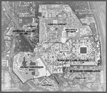
Nizamuddin is a significant area of Delhi best known for the shrine of Hazrat Nizamuddin Auliya, a revered Sufi saint, and the world heritage site of Humayun’s Tomb. The area, inhabited since the 13th century, has seen a profusion of tomb buildings in close proximity to the dargah. Apart from Humayun’s Tomb, Chausanth Khamba and Atgah Khan’s Tomb in the basti and the Sunderwala Burj and Lakkadwala Burj in Sunder Nursery, are some other significant monuments in the area. Sunder Nursery, formerly known as Azim Bagh, located along the historic Grand Trunk road, was later developed by the British as a nursery for new plantation at Lutyen’s Delhi in 1929. The nursery houses several plants that represent the native region as well as exotic varieties brought in by various travellers, especially the British.
The 700 year-old neighbourhood of Nizamuddin is one among the many neglected settlements of the city that has outgrown its resources, its historic past and rich cultural base hidden under the more apparent and visible lack of basic services, poor infrastructure and overcrowding. The settlement, significant because of the Hazrat Nizamuddin Dargah, receives thousands of pilgrims daily; yet it struggles for space, sanitation and opportunity.
In 2007, the Aga Khan Trust for Culture (AKTC) initiated a process of community engagement in the basti with the prime agenda of improving the quality of life of the residents of this heritage zone – a basic element of sustainable development. The resident population of the basti, with a density of almost 70,000 people per square kilometre, needed not just open spaces, access to good education and timely health care, but also a fresh engagement with its own cultural base. The AKTC expanded its programme intervention into a comprehensive urban renewal programme encompassing socio-economic, physical as well as cultural components, based on extensive community dialogue. The aim was to evolve a model of urban development that was culturally ‘sensitive’ and ‘informed’. The belief that Hazrat Nizamuddin Basti can overcome its infrastructure challenges and give continuity to a vital part of the city’s history became the driver behind this urban renewal initiative.
T
he project spent considerable time in engaging with the communities while designing various project components. The process of community dialogue continues to be the guiding principle as various interventions under the project evolve and expand. The community dialogue involved a mapping of all stakeholders starting with local leaders, religious heads, youth, children, women, and men, owners of commercial establishments, vendors and petty shopkeepers.The stakeholder engagement was not limited to the community alone but involved the government and the city of Delhi at large. Extensive dialogue with all stakeholders resulted in a better understanding of community needs, potential and resources. Infrastructural challenges within the basti – especially with respect to sanitation, parking facilities and overcrowding – were highlighted by residents and visitors alike. The lack of basic amenities and, despite its rich cultural fabric, a perception of ‘insecurity’, was a common feedback from pilgrims and visitors.
The cultural mapping of tangible and intangible resources of the basti was carried out by local youth. The mapping exercise listed out some of its unique yet neglected built heritage. It also brought out the intangible cultural resources of Sufi music, local crafts such as calligraphy, crochet and cultural practices such as the celebration of basant and Urs. The cultural resources, historic structures, annual festivals and local traditions were charted out. Neighbourhoods and the sociological parameters that govern their growth, were much better understood through these exercises. While many of the traditional crafts and customs were in people’s homes, the celebration of festivals on the streets and community spaces brought the people together. The know-how from the cultural mapping exercise went into the designing of a heritage walk where local youth trained to be ‘heritage volunteers’ could guide tourists and visitors through the basti streets, thus making them aware of the many layers of history of the area.
T
he dense settlement still retained some of its open spaces and designated DDA parks, although they were neglected and poorly maintained. Over the years, the limited available open spaces were taken over by drug users and became a dumping ground for household and construction waste, preventing the community and its children from using these spaces. The 2009 baseline survey revealed that less than two per cent of the local population accessed these spaces. After careful dialogue with and design inputs from the youth, parents and women, the open parks in the basti were freshly landscaped and redesigned under a MoU with the Delhi Development Authority. One of the parks was specifically designed as a screened garden or pardah bagh keeping in view the needs of the women for a separate and secluded open space. Three of the parks have been landscaped and are today extensively used by the community.The parks used for community and family events have now become the pride of the community. Since 2010, the ‘Apni Basti Mela’ is held every year in one of the parks where the local community showcases its crafts, theatre, music, food and art. Children from schools in and around the neighbourhood participate in the mela. The festival has grown each year and is beginning to attract people from different walks of life interested in the unique history of the area, its food and music.
T
he landscaping of the Chausanth Khamba forecourt has enabled the area to host music festivals. It has now become synonymous with the Jashn-e-Khusro festival organized every alternate year to celebrate the work of the legendary poet Amir Khusro and Sufi musicians and singers. The adjoining space around Mirza Ghalib’s Tomb serves as the backdrop for numerous mushaira and poetry recitals. The urban design interventions around open spaces in the basti, coupled with extensive and active partnerships with the community on its rich cultural heritage, has helped revive its intangible heritage and given new meaning to abandoned open spaces.Apart from the larger open spaces, incidental spaces along streets such as street corners, intersections and roundabouts which had been reduced to serving as the usual garbage dumps, have also undergone significant change. Small actions in these spaces, with the lead taken by children of the community, have made a big impact on their lives. Wall art by children, youth and local craftsmen, along with interventions through the ‘hole in the wall’ computer learning kiosks, have transformed these spaces into positive and healthy learning spaces for children.
The interventions with children in schools and through environment and heritage clubs have made use of neighbourhood streets as exhibition spaces. Children’s work displayed along the streets from time to time, help transform the streets into welcoming spaces for women and children.
A
larger plan for the improvement and upgrading of all streets in the basti has also been drawn up. This was preceded by an extensive physical survey of streets, an infrastructure mapping of water, electricity and sewerage and a visual screening of building condition. The physical survey had not been accurately updated by the authorities for over 75 years and the new maps provided useful insights into infrastructural issues, the activity patterns, neighbourhood layouts and traffic and pedestrian movements in the basti. While many of the streets were paved, the constant repairs to water and sewerage lines had caused extensive damage.
A
comprehensive plan was drawn up with the Municipal Corporation of Delhi (MCD) for street paving and underground cabling and for repair and replacement of water and sewerage lines with the Delhi Jal Board. Nearly 30 per cent of the sewerage system of the basti was found to be permanently choked leading to continuing problems at the household level.Following the repair and replacement of the street infrastructure, the MCD paved the streets of the basti according to the designs prepared by and under supervision of AKTC to enhance the street character, especially near historic structures, and to ensure that further repairs to infrastructure causes least damage to the top surface. The designs were shared with the community and this partnership between the municipal authorities, the community and AKTC gave an equal opportunity to all residents to participate in the development process.
|
|
The revival of these ‘common spaces’, including streets and open spaces, has not only helped improve space design and usage but also enhanced the cultural experience of the residents and visitors to the basti.
I
n 2008, one of the walls of the historic step well (baoli) collapsed. The pressure of urbanization and lack of maintenance of the structure had caused a bulge along the eastern wall which finally gave way, posing a serious threat to 18 families living on top of the structure and the 5000 or so pilgrims who used the corridor each day to visit the dargah. The extensive dialogue over a period of two years with communities and the local government ensured that 17 families were relocated to government allotted plots. As part of the relocation package, the affected families were provided with housing, and support for livelihoods and access to health care, education and pension schemes near their new homes.Simultaneously, a mammoth effort was made to de-silt the step well to its original depth of 80 feet below the ground level. The manual lifting of sludge required over 8000 man-days of work. The inappropriate epoxy layer applied to the baoli in 2002 by the authorities was removed and the collapsed portion rebuilt using traditional building materials and techniques. The original ashlar facing stones that had fallen in the baoli were lifted manually, collected and reused.
Following the completion of the work at the baoli many smaller historic structures around it, such as the unknown tomb or Chini ka Burj, were conserved with the support of the local residents. A housing improvement programme where local residents were able to repair their homes through a cost sharing mechanism, helped improve the condition of 40 homes in the basti. In addition to technical advice and supervision for home improvements, several training programmes on good construction practices using modern and traditional materials were well received by the community.
The development process, especially for historic districts, must craft a delicate balance between the structural heritage of the monuments, the social and cultural heritage of communities that have lived for generations around them, and the economic and infrastructure needs of the area. Even though several urban design interventions in the Nizamuddin Basti have brought about a visible change, it still continues to grow indiscriminately in the absence of an appropriate policy framework. So far the Master Plan has articulated the need for special area plans for heritage zones, including the Nizamuddin area, and the AMASR Act (amendment 2010) recognizes the fact that each monument is unique and the development around it should be guided by a set of by-laws that are unique to its setting.
These two policy instruments provide the first steps to guide development in such areas. Much more, however, needs to be done before significant and sustained improvements will be visible on the ground. As concerned citizens and development professionals, the challenge for us lies in bridging the gap between our history and growing developmental concerns through a participatory and inclusionary process where we look inwards, and seek solutions that are culturally sensitive and sustainable.